A Personal Project that has been a Wellspring of Creativity and Greatly Developed my Skillset…
Tools
- InDesign
- Photoshop
- Illustrator
- GPlates
- NASA G.Projector
Deliverables
- Maps detailing the political and natural world of the game at the local, regional, and world levels
- Publications that exist in the world of the game such as newspapers, flyers, journals, and ephemera
- Rules documents that detail elements that the players have control over, such as their magical items, vehicles, and Non-Player Characters
Overview
Timeline: Jan. 2021 – Present
Play is a vital (and often underutilized) part of developing design skills.
For the past 5 years I’ve been running various Table Top Roleplaying Games (mostly Dungeons & Dragons) for my friends on a weekly basis. And whenever I run a game, I like to design maps, character sheets, flyers, and other design pieces for my players. It helps them more fully engage with the game and is a fun challenge for me.
Collected below is a small selection of material from the current campaign I run for four players (in four different timezones!) and an explanation of my process.
I think these pieces demonstrate not only my graphic design skills but also my ability at information hierarchy and UX Writing. Creating designs that balance in-world verisimilitude and in-game usability is not always an easy task, but it is one that I relish.
Maps
My map building process is heavily-indebted to Artifexian’s Atlas Map Series, which you should absolutely check out if you want to create maps yourself!
World Map Process
Plate Tectonics & Projections
The first step in creating a real-feeling world map is plate tectonics. Using a program called GPlates I map out the major plates on a globe. Then I define the direction that each plate is moving in order to create the tectonic boundaries.
These define where continents will show up and what they will look like. For example, the main continent on this map has a convergent plate tectonic boundary at its center, with the southern plate pushing under the northern. This creates a massive mountain range with a steppe to the north and a fertile basin to the south (i.e. the same conditions that created the Himalayas, Mongolian Steppe, and Indian Subcontinent).
It is at this point that I can roughly map out where continents lie.
Next, I project that tectonic map onto an equidistant rectangular rendering and open that in Illustrator.
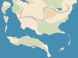
I use a wind map and the relative distance from the equator to determine where ocean currents will be. This shows the likely shape the coast will take, with places being struck forcefully by the currents more jagged and eroded than where currents are more gentle.
Then I establish the relative topography of the landmasses using contour mapping. Now I am almost ready to start making my final map; all I need is a proper projection.
Rectangular maps are projections from a globe, and a good projection gives a map projection artifacts that feel subconsciously realistic to the viewer.
I load the equidistant projection I’ve already created into a program created by NASA called G.Projector. I then pick a projection that will best fit the part of the world my map is focusing on.
Since my final map will center on an equatorial ocean, I pick an equatorial projection.

Natural Topography:
Currents & Coastlines, Mountains & Rivers
Using the equatorial projection as a pattern, I can now start on my final map.
Besides currents and tectonics, other major factors affecting coastline are glaciers and volcanic activity.
I try to include common geographic structures influenced by these features to increase the feeling of realism. This includes island chains that reflect a moving volcanic hot spot in the crust (i.e. Hawai’i) and bays with islands created by glacial terminal moraines from ice ages (i.e. Long Island).
Mountains for the most part follow the lines of major tectonic activity, with their size being determined by that activities type.
Rivers flow off of mountains towards coasts. Many small streams will join overtime to create a larger river, but rivers almost never split (except for at deltas).
Mountains also create “rain shadows” wherein one side of the range is very wet and the other very dry. If the range is long enough, this rain shadow can even flip at different latitudes (think the Andes). This helps me determine where the deserts, lakes, and dense forests might occur.
Unnatural Topography:
Cities & Nations
Almost all very large cities (especially in the pre-modern world) occur along the coasts and major rivers. Of particular note are places with good natural harbors.
Exceptions to this rule include places with exceptional political/religious importance or that are rich in resources coveted by the society. Discovering what those might be is a big part of the fun.
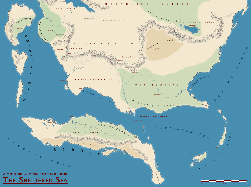
Labeling & Political Maps
My labeling style is heavily influenced by Wikipedia’s WikiProject Maps, a set of standards published by Wikipedia for atlas-style maps made by its contributors.
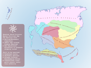
The nice thing about taking your time to create a world map from scratch is once you have it, you can keep finding new ways to use it. For example, I took a different projection showing more of the world and made a political-style nation map out of it which demonstrated the plan that the nefarious villains of the game (a cult of quasi-Immortal wizards) have for world domination.

City Map Process
City and regional maps are in many ways simpler than world maps. You don’t have to worry about the fact the world is a globe for one!
But they will also be used in more granular detail by your players and so need a higher level of detail about terrain. The players in my game recently used one of my city maps to track the progress of a siege. I was sure glad that I’d included all relevant terrain data and didn’t have to make it up on the fly.
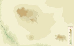
Local Contour Mapping
I like to start by mapping out the elevation of everything on the map using color-coded contour mapping. I’ll pick a color scale that fits the local vegetation (or in the case of this desert settlement, lack thereof).
Contour maps don’t usually include any human activity, unless the humans have fundamentally changed the elevation of something in the area (in this case they actually have: in the lower left quadrant they’ve raised a regularly shaped mound on which to build a fort).
Districts, Roads, & Buildings, oh my!
When I’m mapping a whole city, I don’t want to make every single building. However it’s important to fully model out spots of interest, and I like to keep those buildings to scale. For non-essential buildings I simply map out the various neighborhoods to give the players a sense of what is there.

In-World Printed Material
Publick Occurrences Both Forreign and Domestick
I like my players to feel that the world they are living in is alive and that their actions have a profound effect on it. To work towards this aim, I publish an in-world newspaper, which gives them an insight into what the current trend in world events is.
The paper is named for and has a design based on Publick Occurrences Both Forreign and Domestick: the first newspaper ever to be published in British colonial America.
I always try to include some hidden “plot hooks” in the stories to reward eagle-eyed players who act on the information in the paper.
Ephemera
Some of my favorite design pieces are set dressing. If I want to particularly emphasize some aspect of a place, I will often create flyers or legal documents or correspondence for my players to find that keys them into those elements.
For example the first time my players visited the city of Drydock, I designed several posters and public notices leading to various points of interest in the city. I arranged these posters on a billboard website with a brick wall background and gave my players the link when they entered the city, so that they could experience finding the posters in an authentic way.
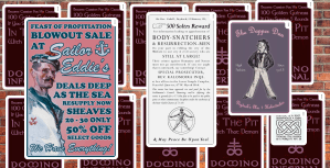
Another example: when my players were first conceptualizing their characters, I asked them questions about who they were and what they cared about.
I used this information to create a piece of printed collateral for each of them that we felt that character might have on their person: a folio of prayers, a college poster, an advertisement for a scam apprenticeship program, and a harlequin romance novel about sailors.
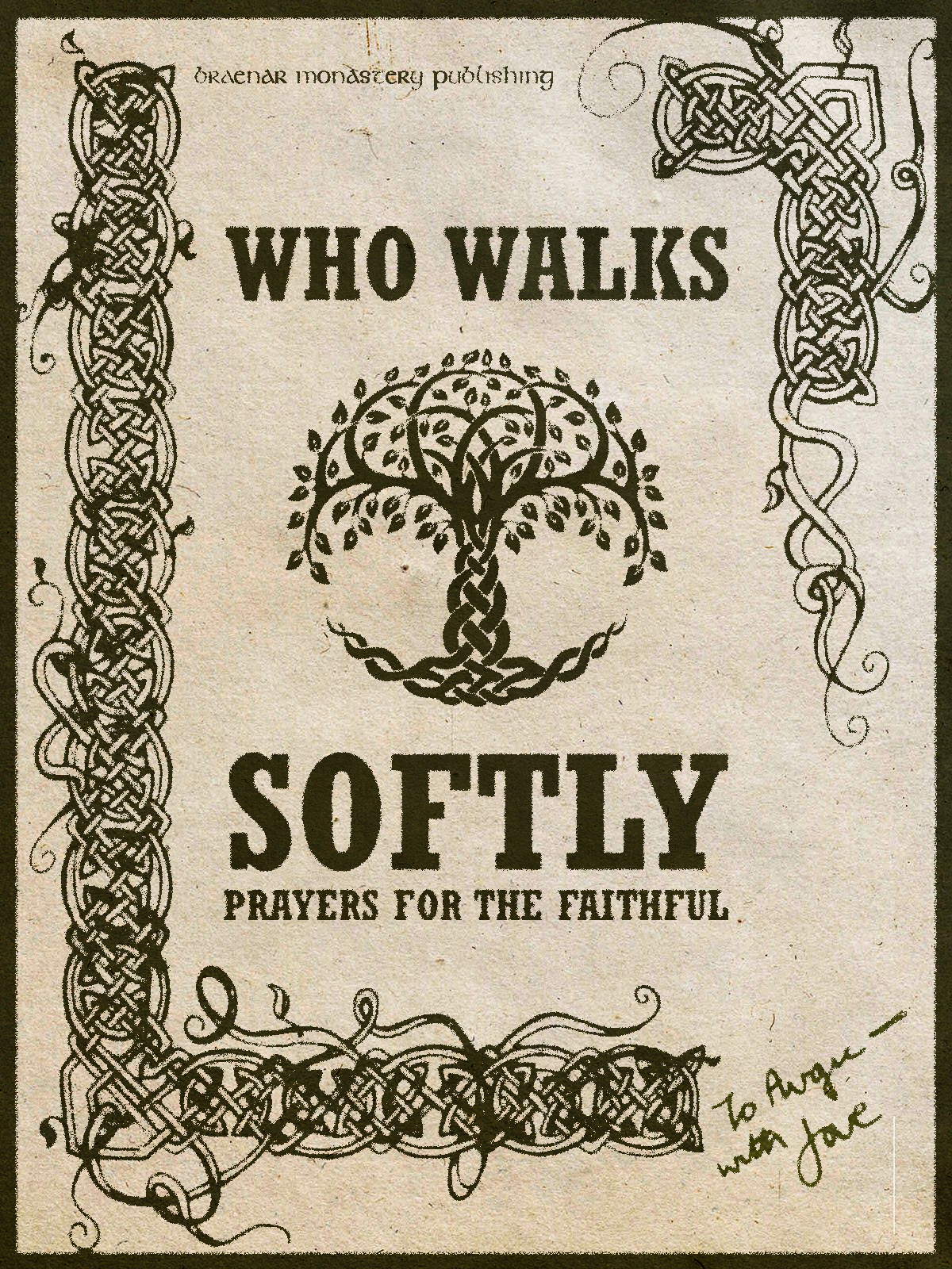
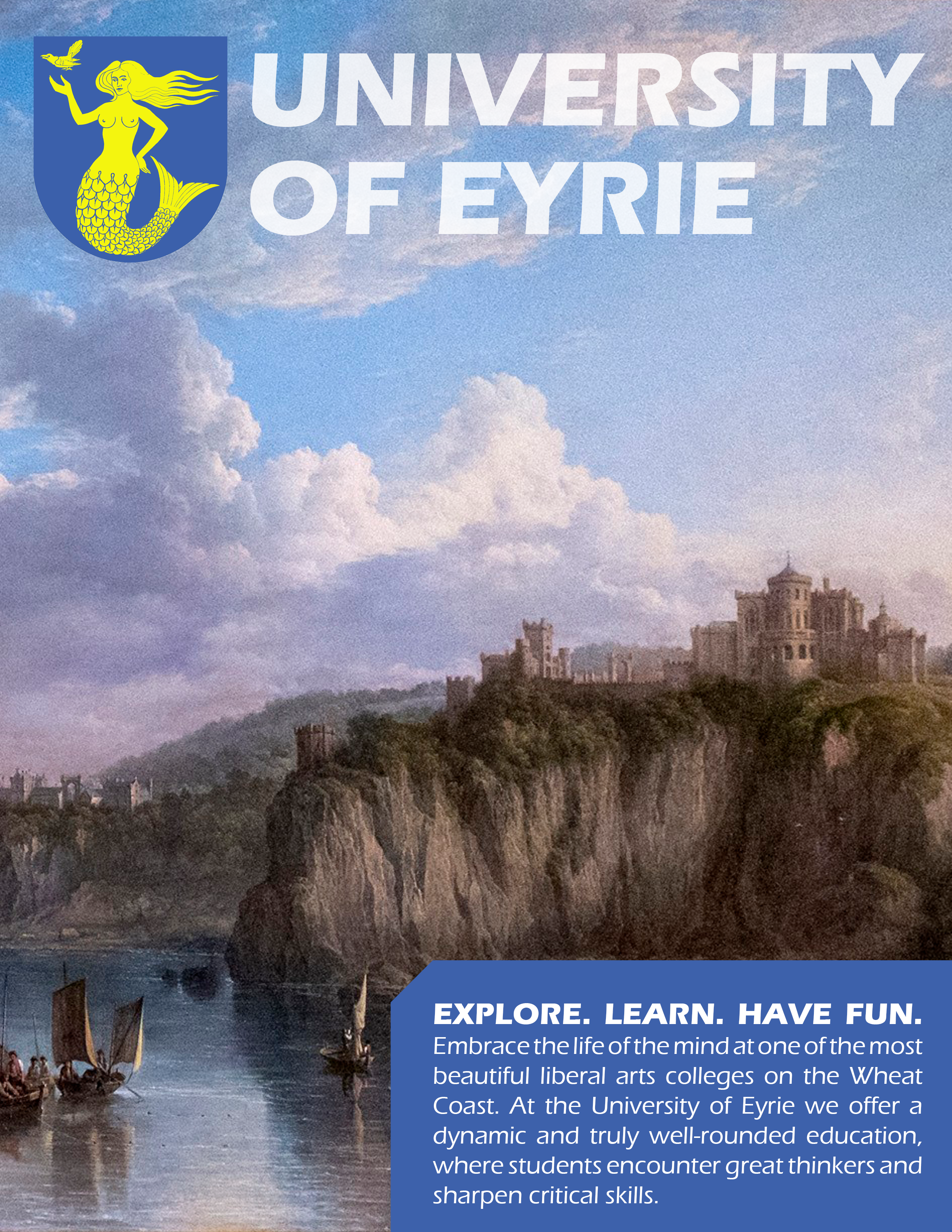

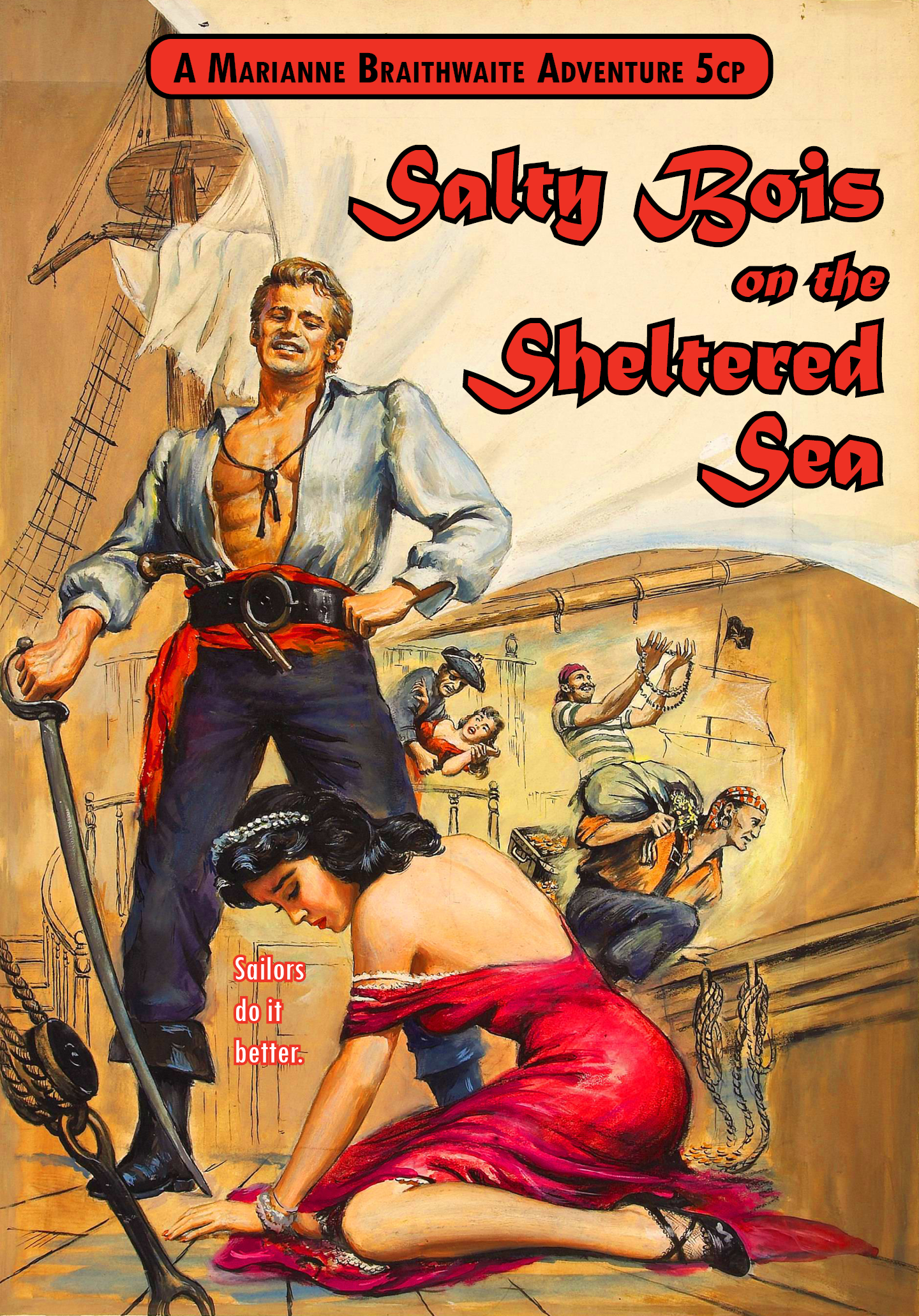
The great thing about ephemera is that I can create anything that will set a mood I want to establish in the game. My options are unlimited.
Rules Documents and Character Sheets
But game design is not limited to what exists in the world of the game. You can also design more directly to the players with documents that enhance their understanding and enjoyment of the game’s rules.
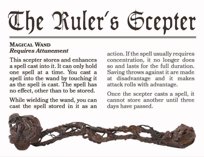
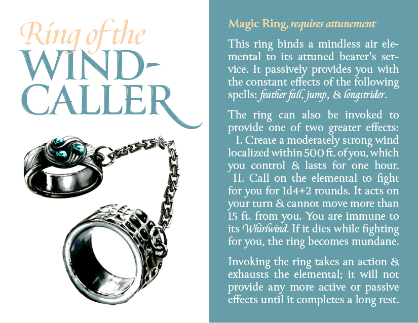
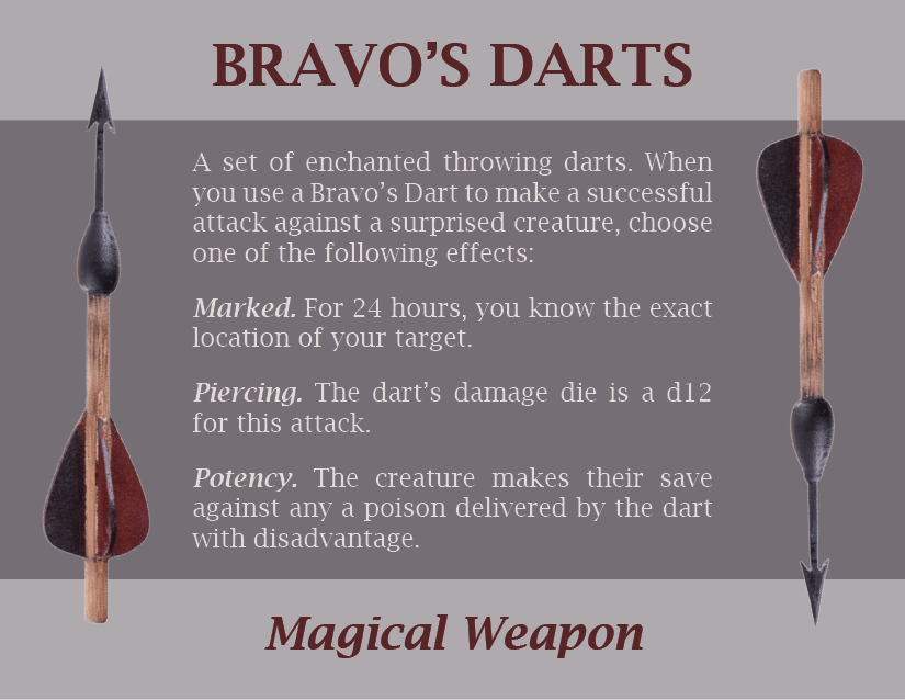
Magic Item Cards
I love making magic item cards. I write all my own magic items, because I can create more unique and appropriate abilities for my players than the generic ones printed in the source books.
Creating a power with interesting uses and (more importantly) interesting limitations is a design challenge all its own. And then I get to create a beautiful card to represent it. I find these easy-to-access cards make my players use their magic items much more, because they remember that they have them.


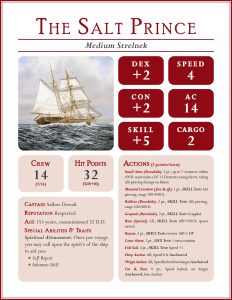
The Ship Sheet
Sometimes you come across something in your game that the rules system hasn’t accounted for. In my current game, the players really wanted to own a ship. They saved up for it and bought one with the treasure from their adventures.
Of course I looked up homemade rules supplements for ships and let them have one. But those supplements didn’t have character sheets for ships, so I designed my own. This sheet allows me to keep track of all their ship’s stats, crew, and abilities.
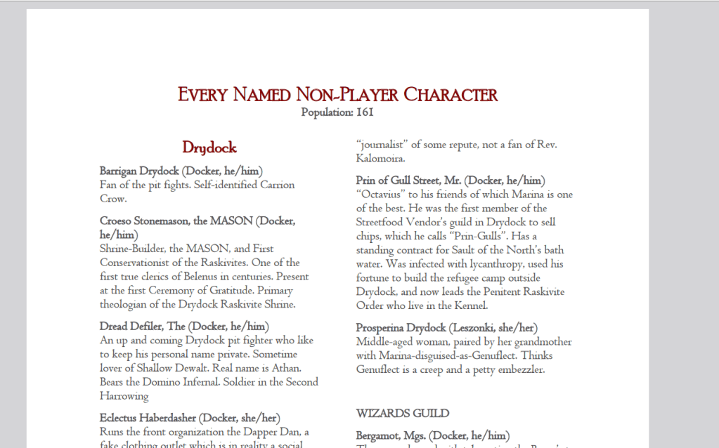
Keeping track of Non-Player Characters
Probably the hardest informational challenge I have in the game is keeping track of all the Non Player Characters (NPCs) and their relationships to my players.
In any given location and on any given adventure, the players will interact with a half dozen people. If they come back to that location a few months down the line, they will want to know what happened to those people, and maybe those people will remember the main characters (fondly or not so fondly, depending on their actions).
This was easy to keep track of at the start, but these days there are over a hundred living NPCs. I’ve created a detailed documentation system for these NPCs broken down by location so that we remember exactly who they are, from the most inconsequential to the most beloved.
Reflections & Takeaways
My design work for role-playing games has been endlessly valuable to me as both practice and an idea generation factory.
And I never get tired of doing it, because it’s fun.
I taught myself Illustrator making maps, kept my InDesign skills current between projects building flyers, and constantly challenge my design and writing skills with this silly game.
If design was just work for me, I would be much worse at this job. But because I can play as well as work in the design space, I always have fresh ideas.
